


Biodiversity Plan for Querrin Creek, Querrin.
2.2 History and culture of Querrin Creek
3 Themes for our biodiversity plan
3.3 Build on our strengths and address challenges
Acknowledgements
We wish to convey thanks to Clare Local Development Company for funding the training which has supported this biodiversity action plan. Thanks also to Tony Whelan, Kevin Heapes, and the local community for their active interest and participation
1 Introduction
We are mainly members of the Querrin Pier and Village Community Development Group with other interested people from the locality. Our group has a commitment to biodiversity written into its constitution and we have already carried out projects to improve the biodiversity of the area, including yearly beach/ waterside and road cleans and restoration of eroded sandbanks to help prevent the loss of our sandbank habitat.
We have many reasons for taking the course one of which is to get help with a Biodiversity Plan for a half acre site which has been purchased by the shore line to create a Bird Hide. We also wish to get a Biodiversity Plan for our local graveyard.
The local area is also about to take over the local National School which is closing and we have the vision that part of its remit will be connected to a Nature Centre (Querrin Nature Quest) with information and education on biodiversity and nature. The nature observatory would link in with the school and be a communication centre for the local population.
2 Description
2.1 Description of the area
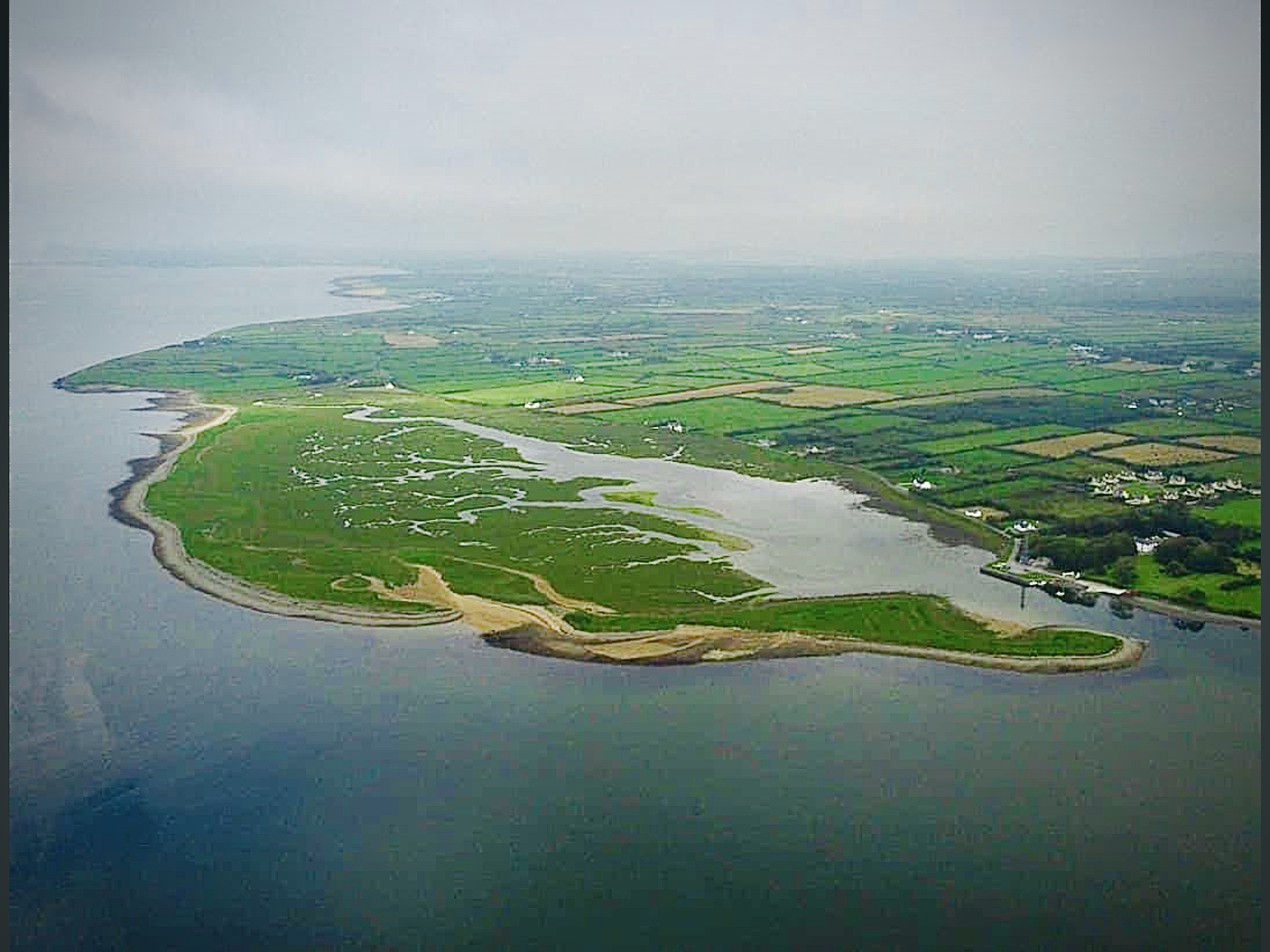
Querrin Head is a narrow spit of land that lies in an east /west direction and is nearly a mile long. It is a sand dune habitat and is unique as it is the only one in Shannon Estuary. It’s north/south dimension is in places only 5 to 15 yards wide at its narrowest and otherwise around 250 to 600 yards wide. It is about 30 to 35 acres in total land mass.
On the south or seaward side, it is mainly a mixture of rocky shoreline with intermittent sand beaches. It is protected by a ridge of rocks and stones rising up and shaped by the sea.
The north side is enclosing a tidal salt marsh estuary which has SPA status. The saltmarsh is confined to a small inlet that opens out onto the main Shannon Estuary at Querrin Point. It is offered protection from all but the worst onslaught of the Shannon’s environmental fluctuations by a long sandy ridge extending eastwards from Corliss Point as mentioned above. Saltmarsh vegetation occurs on both sides of the inlet; indeed, it occupies a significant portion of the intertidal mudflats. The upper limits of the tidal influence in this inlet are easily recognized, as there is an abrupt change in the Spartina sward to brackish vegetation, where an unnamed river enters the inlet alongside the Templemeeagh Graveyard.
The saltmarsh at Querrin is overwhelmingly characterized by the presence of an extensive sward of Common Cordgrass (Spartina anglica). This non-native invasive is commonly found in many of the saltmarsh systems along the lower River Shannon. Local knowledge says it was introduced in 1955 at the same time as was been introduced in Palnasheeer Bay. The site is an estuarine marsh which occurs on mud and gravel. However, a large part of the Annexed saltmarsh habitats occurs on sandy substrates.
The Spartina sward occupies a significant portion of the intertidal mudflats and occurs along both side of the inlet. The majority of the remaining saltmarsh habitats are found along the southern side of the site, between the Spartina sward and transitional area to coastal dune grassland. However smaller discontinuous fringes of ASM and also MSM vegetation are also recorded along the northern half of the site. They are not as well developed as on the southern half and are largely replaced by transitional and brackish vegetation dominated by Common Reed (Phragmites australis) or Sea Club Rush (Bolboschoenus maritimus).
The majority of the Annexed saltmarsh habitats occur inside the confines of the SPA.
Habitats: salt marsh ,sand dune, sandy beach, raised rocky shoreline extending down to low water mark in places. , tidal pools, sandbank( 2miles x1mile)
Plants: sea beet, bladder campion, celandine, yellow horned-poppy, common scurvy grass, sea rocket, sea radish, burnet rose, clover, lesser trefoil, kidney vetch, kidney vetch, common birds-foot trefoil, bloody cranes-bill, sea holly, rock samphire, wild carrot,sea pink, scarlet pimpernel, common centaury, lady’s bedstraw, common eyebright, daisy, sea aster, sea mayweed, perennial sow thistle, common cats-ear,
Birds: heron, little egret, cormorant, Brent goose, great northern diver, sparrow hawk, oyster catcher, lapwing, golden plover, whimbrel, curlew, sanderling, dunlin, snipe, gulls, hen harrier, crow, raven, reed bunting, wagtails
Nesting birds: meadow pipits, skylarks , turnstones , shell duck in rabbit burrows
Mammals: rabbits ,stoat, pine martin
Fish: flatfish, plaice, mullet ,mackerel ,turbot, bass, flounder, ray, pollack, skate, conger eel and herring.
Seaweeds: carrageen is found in a large rocky pool area at low water ,dulce, kelp, sea spaghetti
Invertebrates: razor fish (only breeding area on Shannon Estuary) on large sandbank ( 2miles x 1 mile), cockles, mussels, winkles
Crustacea – Lobsters, Crabs, Prawns, Shrimps and Barnacles
2.2 History and culture of Querrin Creek
Before the Rice Grass was set there was a completely different general habitat. The main difference to today is that it was a true sandbank and the whole inner salt marsh area was solid sand with little vegetation. When the area had a larger population, up to 1940, there was regular football matches held on the sand areas opposite Cassidy’s house.
It was also used to horse ride and races were held.
There was a large salmon weir a few hundred yards from the shore about a third of the way down the spit from the mainland. There was even a shed/ shelter / shanty house to protect the fishermen who worked it and the site can be seen to this day.
Food: The main food to come off the spit was rabbits, mushrooms and seaweed.
Rabbits were mainly snared and the art of setting in runs was learned. You would lay snares and return following morning to check if you caught anything. The downside was when a rabbit was just caught on a leg and died in severe pain. The rabbits if snared properly was strangled very quickly. Rabbit stew was a favorite dish and the art of removing the fur was quickly learnt.
Mushrooms grew at various times of the year on parts of the spit. The main area was just across from the pier in the little valley at the back of the sandy area. Again the joy of rising early, collecting followed by eating fresh fried mushrooms was magic.
Carrigeen was another favorite to collect. At the south side of spit there is a large pool that can be accessed at low tide and where it still grows to this day. It was picked and left on the grass on the sandy shore and between the rain and sun was bleached. It was then collected and used over the year. It was a remedy for many ailments from flu to infection. My memory however is it been mixed in into boiled milk which was then poured into cups and left to go hard like jelly. There’s were then put in sweet bowl with strawberry jam on top and was delightful.
Fishing: As it was a sandy base up until the 1970s it helped in attracting and catching fish. When the tide went out it left numerous pools and a good flow of water. Either the fish chose to stay or were trapped in these pools and it presented a great opportunity to catch them. You had a mixture of fluke, turbot and plaice.
The technique of catching was to walk slowly through the pools and mainly along the sides you would stand on a fish. You would then bend down and catch the fish through his gills with your hands. Some people used hay forks or spears and speared the fish between their toes. The fish were plentiful and you would always come away with a catch. Often there would be a group of us walking up the pool in line hunting the fish. Some would make a dart to escape and give you a right bang on your leg. If a fish escaped he would then be hunted down. Unfortunately, as the Rice grass grew the pools turned into mud and this experience cam e to an end.
Razor fish: on the sandbank east of the Head at low tide razor fish were and still are caught with a spear. A narrow spear is inserted into the blow holes that the shell fish make on hearing you walk on the sand. A bucket of razors can be caught quite quickly depending on the skill of the person.
2.3 Description of our sites
Our biodiversity plan has focused on three sites, all of which are beside the saltmarsh habitat which is in a Natural Heritage Area, a Special Protection Area, and a Special Area of Conservation. They are all in close proximity to each other.
Key to map: 2.3.1 O’Keefe’s site
This is where we plan to locate a bird hide. It is approximately a half-acre in size and includes a cement base where a fisherman’s cottage was once located, surrounded by an overgrown grassy area with gorse which is becoming difficult to walk through, and a line of old damson trees which may have once formed a cottage garden. It is bordered by the road on the west side and the sea on the east and south. Its northern border runs into a field with no fence to mark the boundary. The field is sedge-rich and species diverse and we found Sea arrow grass here which indicates an upper salt marsh habitat. The site is a reclaimed piece of land and it is open to flooding at high tides.
The verge beside the lane here is also species rich with spotted square stalked St John’s wort, cut leaved geranium, bittersweet and soft shield fern. Stonechats and skylarks are present
2.3.2 Bradley’s site
This is a small area, less than ½ hectare, with a road on its westerly side and otherwise surrounded by water. It is fully covered in trees mainly willow and hawthorn and is difficult to access. Like O’Keefe’s site it was originally the site of a fisherman’s cottage.
2.3.3 Templemeeagh
Templemeeagh is an old graveyard with a small parking area beside it. The site is bordered on the east side by the road and access to the carpark and graveyard is from this side. The creek extends on the south and west sides. The east side has an earthen wall bordering a field. There are approximately 118 graves and 48 of them have unknown records. The main habitats are the old stone wall which forms the graveyard boundary, grassland around the graves, the dry, sunny gravelly habitat of the carpark, and ditches.
The stone wall boundary of the graveyard is covered in ferns including rusty back fern, maidenhair spleenwort and black spleenwort all of which belong to the genus Asplenium. They indicate the wall is maintained carefully without use of herbicide or power washing.
The grass in between the graves is predominantly composed of vigorous growing species such as cocksfoot and Yorkshire fog which have outcompeted native wild flowers. It is heartening to know that the grass around the graves is cut by hand and not treated with herbicide.
There is some dumping of green waste, including items from graves. This green waste will leach nutrients into the soil which will encourage the vigorous grasses further and we plan to introduce a composting system to ensure that the green waste piles do not contribute to climate change by releasing carbon dioxide and methane.
The proposed car park area is dry, gravelly and sunny with abundant birds foot trefoil and red clover We will consider keeping a gravel car park area rather than tarmac which has a harsh impact on the immediate environment.
There is one small clump of Spanish bluebell in the graveyard which can be distinguished from our native bluebell by having flowers all around the stem, whereas native bluebells have the flowers on one side only which causes the characteristic drooping. Spanish bluebell is a controlled invasive alien species (EC(Birds and Natural Habitats) regulations SI477 (2011)) which makes it an offence to knowingly disperse it or allow it to escape. We will recommend that this is dug up and the bulbs rotted in a barrel of water and we will alert local residents and ask them to check the bluebells they have in their gardens to make sure they are native and not invasive.
Hemlock water-dropwort (Oenanthe crocata) is abundant everywhere. Awareness raising is important as all parts of the plant are very poisonous. It is important not to disperse this by cutting it when the seeds are setting. This species is becoming increasingly frequent and it may be a result of climate change.
3.1 Habitats
- Grassy area habitats: species-rich lane verges, overgrown grassy areas (Templemeeagh, O’Keefe’s, Bradley’s), grassy habitats that are dry and sunny with thin soil (car park area beside Templemeeagh, O’Keefe’s).
- Damson trees at O’Keefe’s
- Old stone wall (Templemeeagh)
- Other trees and hedgerows
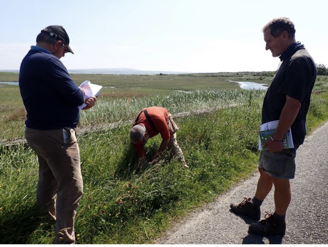
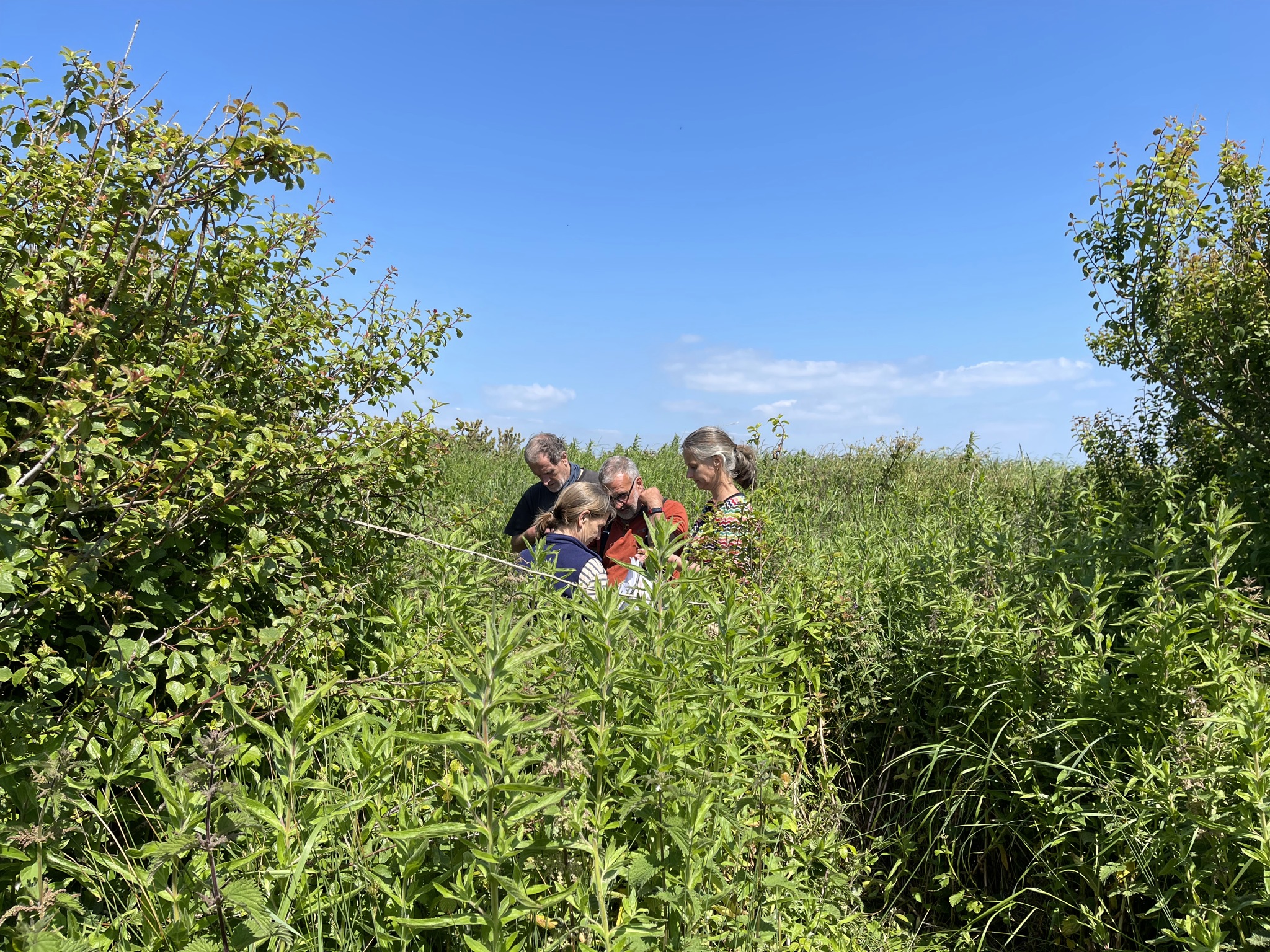
- Quadrats are our main tool for understanding the species composition of grassy areas. In June 2021, the results of our quadrats were as follows:
Site 1 Quadrat: 40% grasses and 60% forb little thatch or bare soil. Vegetation was 45cm and grasses were fescue, rye and meadow foxtail. Forbs were white and red clover, plantain, birds foot trefoil, knapweed and vetch.
Roadside Quadrat: 35% grasses, 40% forb, 15% thatch and 5% bare soil. Vegetation was 30cm with fescue. Forbs were as above
Site 3 Quadrat: 90% grasses, thatch was 10% ,0% forb and 0% bare soil. Height of vegetation was 48cm. the grasses were Yorkshire fog and cocksfoot.
3.2 Education
- The masterplan for our biodiversity project is to link it into an overall plan with the local school which is soon to become the property and responsibility of the Querrin people. The idea is to use the bird hide/nature observatory and school as a centre for awareness, education and enjoyment centring on biodiversity.
- We plan to construct a bird hide at O’Keefe’s.
- By increasing biodiversity in grassy areas, by protecting habitats, and by composting green waste we are helping to sequester carbon. This is critical to help slow down climate change. We will use our biodiversity plan to raise awareness of climate change and encourage the community and visitors to act now to protect biodiversity by explaining that habitats with high species diversity stores more carbon than habitats with low biodiversity.
3.3 Build on our strengths and address challenges
Strengths
- Our sites lie in a Natural Heritage Area (NHA), and adjacent to a Special Protection Area (SPA), and Special Area of Conservation (SAC). We have built actions into our biodiversity plan which support the protection of the protected habitats.
- An actively engaged and educated community with strong environmental interests.
- Knowledge about the history and culture of Querrin Creek from members whose families have lived here for generations. We have records of the biodiversity in the area that go back 50 years and the National Biodiversity Data Centre hold substantial records for the area.
- Access and permissions have been approved.
- A very rich biodiversity in the area with habitats that are becoming increasingly rareWe are building a photographic record of the wild flowers, particularly forbs in the grassy areas.
Challenges
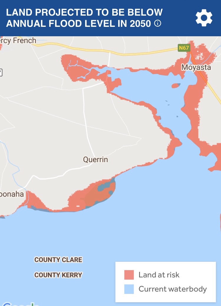
- There is an increasing risk of flooding which now happens on a more regular basis when tides and winds come together in certain patterns, mainly spring tides with south east gales. Map 1 shows the potential problem in 2045.
- Montbretia is spreading in the area and there is a large New Zealand Flax which needs removing. There is Spanish bluebell in the graveyard.
- Grassy areas at all three sites have become overgrown and require skilled, ongoing management
- Ownership problem with part of the meadow at O’Keefe’s claimed by a local farmer
- Local dumping of green waste and rubbish
- Increased footfall from more visitors creating pressure on the fragile habitats
4 ACTION PLAN
2021-2023
Action When O’Keefe’s Finalise legal and insurance elements Sept or Oct Strim high a wide path so grasses at an average height of 5 to 40 cm and remove clippings as far as possible Sept or Oct Compost clippings At the same time as cutting grass Control gorse and brambles by cutting back by hand, leaving some as a winter habitat for birds Oct or Nov Cut back vigorous vegetation around the damson trees to provide access and to protect them Sept or Oct Decide on the location of the bird hide based on how biodiversity can be best protected. Plan to construct it on a high platform on or near the existing cement base rather than constructing it in a sensitive habitat. Explore eco-friendly options for its construction. Sept to Dec Plan how to best remove the New Zealand flax. This is best done by hand to minimise disturbance to the surrounding area but a small digger can be used when the bird hide is constructed. Oct to Dec Bradley’s site Obtain permission from the owner to access the site Sept Strim high a wide path so grasses are at an average height of 5 to 40 cm and remove clippings as far as possible. Strim to create access only. Sept or Oct Plan to protect this willow habitat which is an excellent habitat for biodiversity by adopting an approach of minimum interference combined with raising awareness of all the species that live in and on willows. Sept onwards Templemeeagh Consult the community who visit the graveyard to let them know how we plant to protect the biodiversity here and seek their co-operation Sept to Nov Organise a Graveyard committee to instigate the biodiversity plan for graveyard. Sept to Nov Cut grass high to maintain an average height of vegetation at 10-30 cm. Cut late in the season to minimise risk of dispersing seed of hemlock water dropwort Sept to Oct Thank the community for not using herbicide on and around the graves Sept to Nov Remove Spanish bluebell and rot in a barrel of water Sept to Oct Gather seeds of native meadow flowers and scatter through the grassy areas July and Aug General Plan where and how to compost green waste using Linda’s handouts Sept Raise awareness in the community about the negative impact of green waste and how it contributes to climate change Sept to Dec Plan how the biodiversity plan can contribute to the Nature Quest Centre in Querrin school Sept onwards 2022 and 2023
Action When O’Keefe’s Maintain the path by stimming and removing clippings. Mid April Compost clippings At the same time as cutting grass Carry out quadrats in the gravel area at the entrance, in the longer grassy areas, and along the lane verge. Keep records May to July Construct the bird hide Spring Remove New Zealand flax and dispose of appropriately (removed to green waste facility if possible, Inagh or elsewhere) Jan to April Invite an ecologist to conduct a survey of the sedge-rich field beside O’Keefe’s June Construct a seating area When funds are secured Bradley’s site Leave undisturbed if possible or cut a path to access Observe and record birds and other wildlife. Keep records All year Templemeeagh Cut grass and compost grass clippings Mid April Carry out quadrats and record observations May to July Cut at the end of May and end August to reduce vigour of grasses End May and end Aug Create more permanent grass pathways so the graves can be visited As necessary Maintain stone wall habitat by cutting out ivy and woody species as necessary All year Raise awareness of the biodiversity of old graveyards by building a photographic record and recording species All year General Raise awareness in the community about invasive species, particularly montbretia and ask te community to help stop its dispersal All year Inform National Parks and Wildlife Service about the biodiversity plan and summer Invite Birdwatch Ireland and other nature experts to give talks and guided walks for the local community to raise awareness of the precious habitats in the area Spring and summer Download free template from National Biodiversity Data Centre and erect signs to inform the public of the biodiversity actions at the sites Spring


No Comments
Add a comment about this page